Fifty-five kilometres of beaches, a desert in the middle of the Atlantic, a wreck stranded on the sand, and eighty per cent of the island that you can only reach by 4×4. What you need to know before hiring a car, and which beaches you can actually swim at.
Updated · August 2026Reading time · 10 min
620km² · flat island
55km of beaches
18km · Santa Mónica
1480discovered
6km · airport ↔ Sal Rei
3zones
Boa Vista is the closest of the Cape Verde islands to Africa, and you can feel it. Saharan sand got here before the tourists did: a third of the island is a desert of white dunes, the rest a stony plain dotted with tiny villages. People come for the beaches and leave remembering the silence above all.
It is also an island you have to earn. Sal Rei and its handful of beaches can be done on foot; everything else needs a suitable vehicle, and often a proper 4×4. The tracks bog you down in sand, distances are deceptive, and on the finest beaches there is absolutely nothing: no beach bar, no shade, no help.
The essentials before you go
Getting thereAristides Pereira International Airport, in Rabil. Direct flights from Europe, and inter-island connections with the shipping company CV Interilhas.
Getting into townSal Rei, the main town, is 6 km away. Pick-ups run a shuttle service; aluguers (the shared minibuses or pick-up taxis that link towns) go from the airport to the town centre.
TaxisNo meters, and fares are often very high. Agree the price before you get in.
Getting aroundCars and quad bikes can be hired locally. For the south, east and north, a 4×4 is not a comfort but a necessity.
Don't missNossa Senhora de Fátima, Praia do Chaves, Praia Santa Mónica and the Faról de Morro Negro.
Getting your bearings
The island in three zones
Sal Rei and its surroundings, the desert west and south, the wild east and north. Click a zone to keep only its places, on the map and in the list.
Zone
Beach Village Sight & curiosity
Good to knowThe positions of the points are approximate and are there to give you your bearings, not to navigate by. Several of these places lie at the end of unmarked tracks.
The question everyone really asks
Which Boa Vista beach, and can you swim there?
Every beach on Boa Vista is beautiful. They are not at all equal for swimming: between calm Estoril and Santa Mónica, deserted and with no help at all, the gap is enormous.
Beach
From Sal Rei
Access
Swimming
How to read the swimming column“Take care” means swimming is possible but the rollers or the lack of shelter call for vigilance. “Dangerous” means the currents or waves have a treacherous reputation, and there is no help on the spot.
Sal Rei, the bay and the Ilhéu.
Zone 1
Sal Rei and its bay
all on foot3 beachesthe harbourwhere to stay and eat
The island's only real town, and the only zone you can explore without a vehicle. You sleep here, you eat here, and you set off from here every morning.
The historic centre
on foottown centre
Sal Rei owes its name to the “royal” quality salt once produced by a nearby salt pan, now abandoned. Of the colonial houses, those sobrados (two-storey colonial townhouses) that bore witness to the prosperity of old, only ruins remain.
The heart of town boils down to a rectangular esplanade around which most of the activity gathers. But it is in the lanes that things happen: colourful houses with pink tiled roofs, and groups of men competing at ouril, a board game cousin to awalé.
The best timeThe sleepy-village feeling fades as the day goes on. Late in the afternoon, the first notes of music drift out of the bars on the central square and the boats come back from fishing.
Sodade, Casa da Cultura
on footcentral Sal Rei
This former 19th-century residence, home to a French priest known as Padre Guy, has been restored and turned into a place of remembrance. The decoration and furnishings typical of Cape Verdean colonial houses have been recreated: furniture, paintings, period photos, knick-knacks.
You can also simply have a drink in the shaded, flower-filled patio. Small concerts on Friday and Sunday evenings.
Museu dos Naufragos
on foottown centre
Three floors in an elegant white limestone townhouse. The basement descends into the depths of the ocean, among pieces of wrecks and objects recovered from the seabed, including those with which slaves were traded in the 15th and 16th centuries. You “come back up to the surface” on the first level, devoted to Cape Verde's cultural heritage.
Friday eveningDrinks and live music on the flower-filled terrace of the second level. It is the best time to come.
Nossa Senhora de Fátima
30–45 min on footto the north
A small chapel set on a hill facing the sea, built in 1928 thanks to a donation from the Ben Oliel family, who came from Morocco in 1872 and made their fortune in the livestock and pottery trade. Left abandoned for a long time, it was restored in 2015 and returned to worship; it holds about twenty people.
Getting thereFrom the town centre, take the road north towards Boa Esperança. Past the cemetery, follow the track that leads to the hill. Allow 30 to 45 minutes' walk.
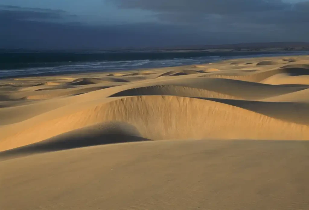
The Viana desert.
Zone 2
The west and south
4×4 recommendedRabilViana desertSanta Mónica
Stony plains scattered with date palms and coconut palms, then endless dunes that spill into the sea. The most arid part of the island, apart from the Rabil valley.
Rabil, the island's breadbasket
10 km to the south3h on footor by taxi
A genuine oasis: the ribeira (seasonal river valley) of Rabil concentrates Boa Vista's food crops and livestock. It is easy to see why it was the island's main settlement until the 19th century, before tourism shifted the centre of gravity towards the coast.
From the harmonious if dilapidated São Roque, the oldest church on the island (1801), you climb to the upper part of the village: from there you take in the old cemetery, the airport runway and the green valley that leads to Estância de Baixo and then the desert.
AlsoRabil is the cradle of Boa Vista pottery: a clay deposit close by supplied a renowned workshop until the end of the 1920s.
Deserto de Viana
4×4 or quad essential3 km north of Rabil
A Sahara in the middle of the Atlantic: the Viana desert's dunes of fine white sand, nature in the raw. Its origin lies in persistent drought (the climate is similar to that of the Mauritanian coast, which the island almost faces) but also in a geological phenomenon: Boa Vista is covered in sedimentary deposits laid down by a period of submersion.
On siteAt the edge of the desert, a bar-restaurant offers stargazing through a telescope and sandboarding. It is the only service point in the area.
Povoação Velha
road then tracksouth of the island
This small town was born in the 17th century thanks to the presence of several springs. This is where Boa Vista's story began. A peaceful, welcoming village with colourful houses and a large shaded square. To spend the night, ask the shopkeepers: they will know how to point you to a room in a local home.
Essential stopThe poor paved track (about 10 km) to Santa Mónica starts from Povoação Velha, as does the road to Praia da Varandinha, 5 km away.
Curral Velho and its islet
stony tracks30 km to the south
The hamlet that once housed a fishing community and a small salt pan has gradually been abandoned: all that remains are a few ruined houses and a wild beach made of coral fragments. The coastline is protected as a loggerhead turtle nesting site.
Reached by boat, the islet of Curral Velho lies 600 metres offshore. It is one of the best bird-watching spots in the archipelago, with endemic and migratory species alike; enthusiasts come for the colonies of boobies.
Local colour
The Cabo de Santa Maria
One phenomenon is unique to Boa Vista: the number of ships wrecked on its coasts in the 19th century. Explanations put forward include the poor charts of the time, magnetic disturbances caused by the island's geological make-up, the scarcity of lighthouses, and a north equatorial current.
The real reason is simpler. In times of crisis, the people of Boa Vista tied a lantern to a donkey's tail and led the animal along near the reefs to mislead ships and make them run aground, then took the moia, everything salvageable on board.
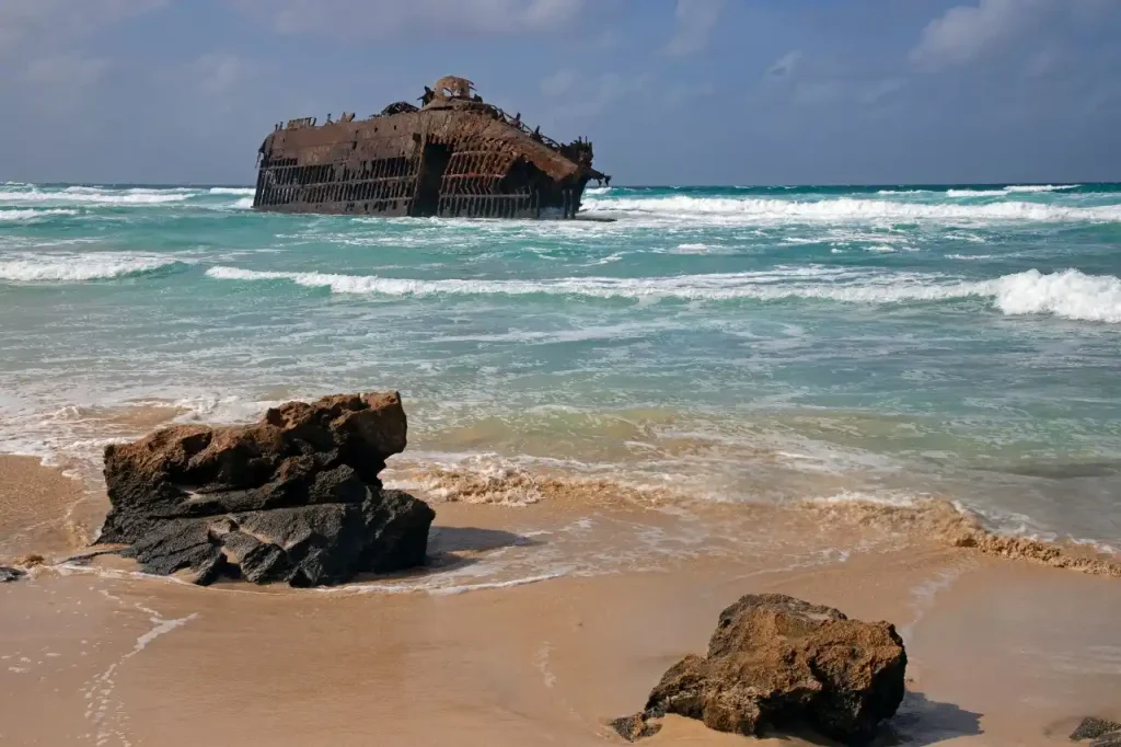
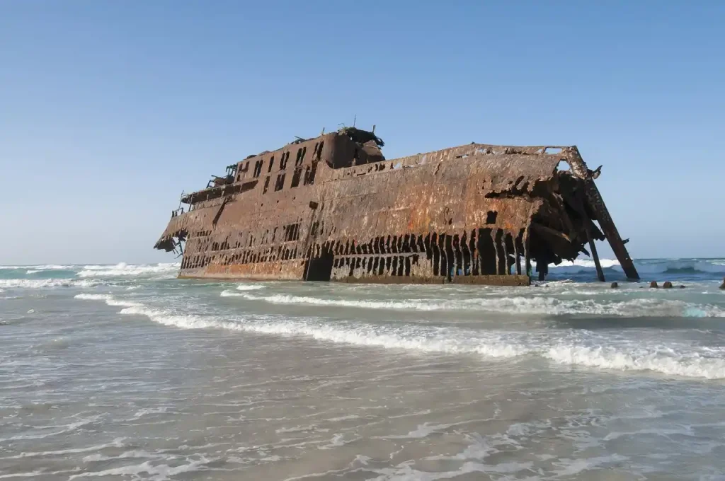
The last of them, in 1968, was the Cabo de Santa Maria, a 131-metre Spanish ship bound for Brazil. Its wreck still lies on the deserted beach of Atalanta, in the north of the island: a strange, massive heap of rusting metal sitting on the shore. It remains one of Boa Vista's main attractions, and one of the hardest to reach.
The wreck of the Cabo de Santa Maria, Atalanta beach.
The eastern plain and the Morro Negro lighthouse.
Zone 3
The east and north
4×4 or quadFundo das FigueirasMorro Negroturtles
Barren, rocky land punctuated by green patches, tiny villages, and the island's wildest coast. This is the part that demands the most commitment, and rewards it best.
Fundo das Figueiras
28 km to the eastvia Bofareira or Rabil
Colourful, flower-lined houses border the main road. Fundo das Figueiras does not look like a herders' village: this neat farming town grew up on one of the few stretches of fertile land in the east. Pigs, goats and cows are raised here, and you can buy an excellent queijo de cabra, the goat's cheese that is one of Cape Verde's specialities. In the centre, the little white and blue church of São João Baptista looks splendid.
Good to knowThis is the lunch stop for the whole east of the island: there are a few restaurants, a rare thing in this area, simple, well kept and serving generous grills.
Cabeça dos Tarafes
several bad tracksabout 30 km to the east
A remote village tucked into the middle of a vast desert plain that you reach after leaving the main road. Few inhabitants, lunar landscapes, and that feeling of being in the middle of nowhere which the island reserves for those who follow the tracks to the end.
Linking it upAfter your visit, retrace your steps and push further east to the Morro Negro lighthouse, then Ponta Ervatão beach, a prime sea turtle nesting site and an ideal spot for surfers.
Faról de Morro Negro
about 5 km from Cabeça dos Tarafesby a track
This is the closest point to Africa. Built in the 1930s, the lighthouse was then the most powerful in the archipelago; today it is disused and falling into advanced decay. If you are not prone to vertigo, the narrow staircase leads to the top of the twelve-metre tower; be careful not to hurt yourself.
The effort is rewarded. The landscape is surreal and fascinating, often swept by violent winds. Like something out of a Jules Verne novel.
João Galego, Espingueira, Bofareira
north coast3 km between the villages
Coming from the east, you travel several kilometres through dunes and dry plains to reach the north coast. The landscapes give way to patches of cultivated land around João Galego. Three kilometres on, Espingueira, a former fishing village long abandoned, is coming back to life with the building of several houses.
This is the wildest and emptiest coast of the whole island, and swimming here is dangerous. On the way back, turn left towards Bofareira, a pretty village of houses painted in dazzling colours.
On the island
Things to do in Boa Vista
Wind and water, essentially. Boa Vista is a destination for wind and water sports before it is one for sightseeing, and a major site for turtles and whales.
Wind and water sports
Spots in the north (Espingueira), the south (Lacação) and at Sal Rei (Estoril), open to all levels. Surfing, kitesurfing and windsurfing can be learned on the spot, equipment included. A long-established club on the island gives lessons in French.
Humpback whales
They visit Cape Verdean waters in spring. The giant reaches 25 tonnes, sometimes exceeds 15 metres, and its song in the mating season is famous. Trips by motor yacht last about 3 hours.
Loggerhead turtles
Boa Vista is one of the Atlantic's major nesting sites, and turtle watching here is closely controlled. Access to the beaches concerned is strictly regulated during the season: you can only go accompanied, with an approved association.
Underwater
Diving and snorkelling for all levels, in small groups. The corals of Gatas bay are the most accessible place to observe them.
Stars
The total absence of light pollution above the Viana desert gives it one of the best skies in the archipelago. Stargazing trips are organised from Sal Rei, in very small groups.
Pottery
Rabil keeps alive a ceramics school born from a local clay deposit. You can follow the whole process there, from clay to finished piece; terracotta turtles are the island's emblematic souvenir.
Two hikes
Hike 1
From Sal Rei to Boa Esperança
Durationhalf a dayDifficultyhard
Below Sal Rei harbour, take the road that follows Praia do Cabral northwards. The sandy landscape gradually turns to rocky, arid ground. A hill appears bearing an old Jewish cemetery, restored a few years ago, next to the chapel of Nossa Senhora de Fátima.
Then the scenery changes: on the Boa Esperança coast, endless dunes lead you all the way to the wreck of the Cabo de Santa Maria.
Don't set off withoutWater bottles, a hat and sun protection are essential. The sun is merciless and the way has not a minute of shade.
Hike 2
From Sal Rei to Rabil
Durationjust over 3hDifficultyeasy
Head due south, towards Rabil airport. Leave the new tarmac road and take the old one, which starts on the left behind the petrol station. Along this wild trail you cross the dunes. Before the airport, turn left at the bridge: the route is waymarked as far as the little valley of Estância de Baixo.
The returnRetrace your steps, cross the bridge and follow the beach back to Sal Rei. An invigorating walk, and the only hike on the island that needs no special preparation.
When to go
What depends on the season
Temperatures hardly change from one end of the year to the other. What changes is the wildlife, the wind and the rains.
A caveatThese windows are rough guides, not guarantees: both nesting and the passage of the whales vary from year to year. Local operators can tell you where the current season stands.
Music
The cradle of the morna
Boa Vista is said to be the cradle of the morna, that haunting lament, Cape Verde's melancholic signature music, carried to the ears of the whole world by the voice of Cesária Évora. As early as 1890, the crews of the Brazilian ships that came to load salt at Sal Rei were peddling the modinhas brasileiras and other love songs from their terra.
Also influenced by fado, the morna has its roots in slavery and in the permanent revolt expressed in lamentation against the settler's oppression. In Boa Vista it finds fertile ground in the economic and social reality of the “little country”.
The pain of exile, separation from a loved one: the morna evokes love, the sea and fidelity just as much, and carries within it the famous saudade, that longing to return, and the unspeakable joy, known only to those who have lived far away, that it brings when it is finally fulfilled.
Where to stay and eat
Where to eat, drink and sleep
Thirteen places, filterable by type and by area. They cover Sal Rei, the desert and the east of the island.
About these places
These places are reference points taken from travel guides, not places tested on the spot. Opening hours and phone numbers are deliberately not listed: they are the details that go out of date fastest, so check them before you go.
Before you go
What to prepare
The vehicle
The central question of the trip. A small city car is enough for Sal Rei, Rabil and Chaves. Everything else (Santa Mónica, the wreck, the east, the north) calls for a proper 4×4. A quad bike is an alternative, but not over long distances.
Water and shade
On the finest beaches there is nothing. No beach bar, no parasol, no help. Two litres per person, a hat, and something to eat if you are going for the day.
The rollers
The wind that delights kitesurfers raises serious waves. Several superb beaches are dangerous for swimming, and children must keep well away from the water there.
Getting stuck in sand
This is the most ordinary risk and the most annoying. On the dune tracks, don't set off alone, tell someone where you are going, and put yourself in the hands of an agency for the trickiest access points.
There is nothing, truly nothing, around. That is exactly why you go.